

Why it matters when buying land
The plat is often the clearest picture of what you are actually buying. It shows the lot's exact dimensions and shape, where road frontage is, and where recorded easements and building restrictions sit — details a listing rarely spells out.
Many deeds describe property by lot and block number on a recorded plat, so the plat is effectively part of the legal description. If the plat shows a drainage easement or a platted-but-unbuilt street crossing the lot, those burdens come with the land.
Plats also reveal context: how the surrounding lots were laid out, what was dedicated to the public, and whether the lot you are buying was ever legally created in the first place.
How to check it
Request the recorded plat from the county recorder, register of deeds, or the local planning department — many counties now publish plat books online. The deed's legal description usually cites the plat book and page, which tells you exactly which plat to pull.
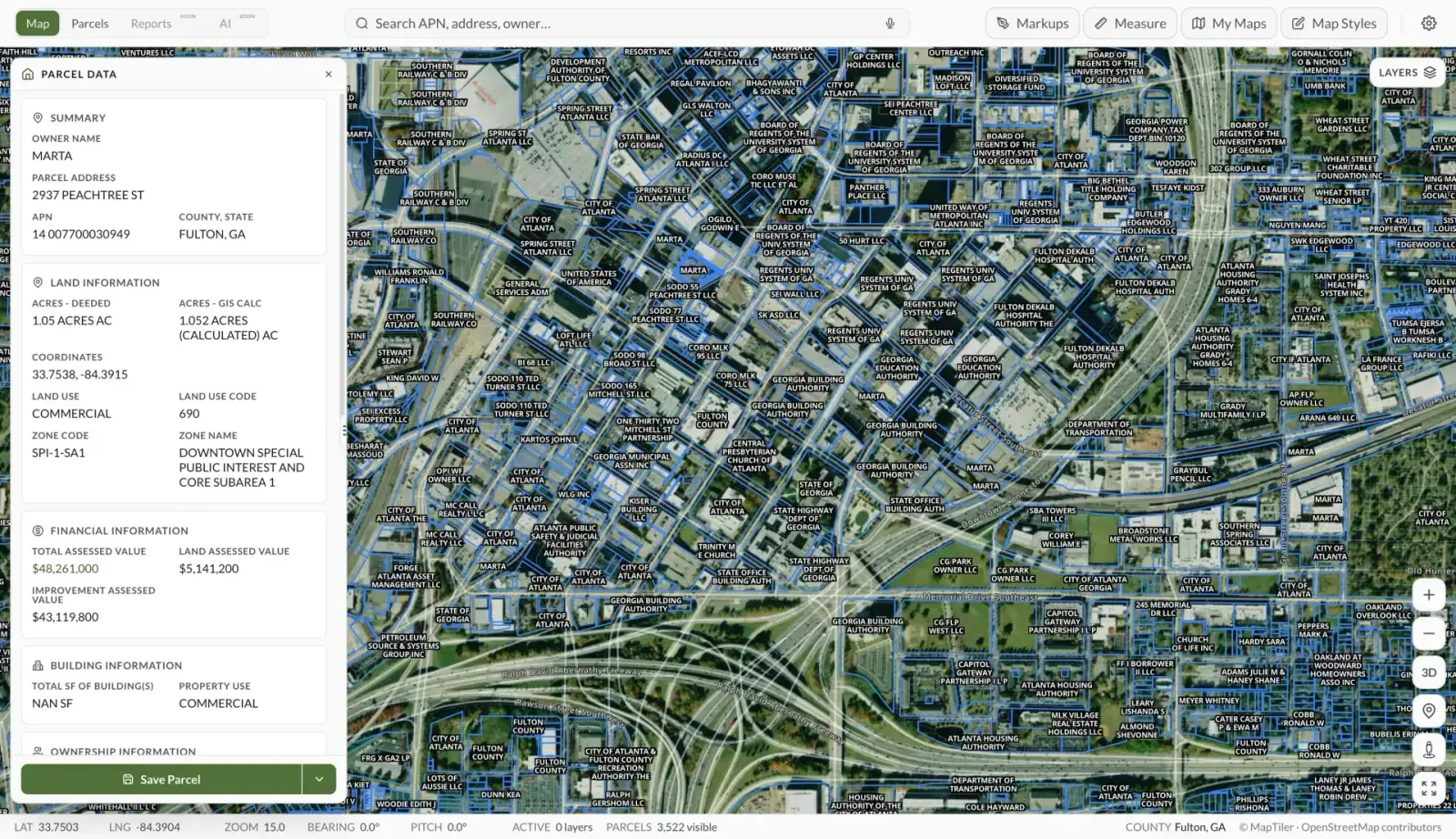
In Land Owl, the parcel boundaries on the map show the lot's shape, dimensions, and how it relates to roads and neighboring parcels — a fast way to compare what is on the ground against what the plat depicts.
For anything you intend to build against — a fence on the line, a structure near a setback — pair the plat with a current boundary survey, since plats can be decades old and monuments on the ground move or disappear.
See it on a real parcel
Land Owl overlays zoning, ownership, flood risk, and more on every parcel — before you commit a dollar.
What does a plat map show?
A typical plat shows lot boundaries with bearings and distances, lot and block numbers, total acreage or square footage per lot, and the streets serving the subdivision. It also maps recorded easements, building setback lines, and areas dedicated to the public, such as roads, parks, or drainage.
The surveyor's certification, the approval signatures of local officials, and the recording stamp are what give the drawing legal weight.
How is a plat map different from a survey?
A plat documents how a larger tract was divided into lots and is recorded for the whole subdivision; a boundary survey is a current, parcel-specific measurement of one property prepared for one client. The plat tells you how the lot was created; the survey tells you where its corners are on the ground today.
For a purchase, the plat is a research document and the survey is the verification document — careful buyers use both.
Where can I find the plat map for a property?
Start with the county recorder or register of deeds, which holds the official plat books, and the planning or GIS department, which often hosts searchable copies online. Title companies also attach the relevant plat to title commitments.
If the deed describes the land by lot and block, the cited plat book and page lead you straight to it. Properties described by metes and bounds may never have been platted at all.
Are plat maps legally binding?
A recorded plat is a legal document: the lot lines, easements, dedications, and notes on it bind the lots within the subdivision. Restrictions printed on the plat — like building lines or drainage easements — generally run with the land.
That said, a plat reflects conditions at recording. Later lot-line adjustments, vacations, or re-plats can supersede parts of it, so always check for amendments in the county records.