Feature
Directions: how far is that parcel, really?
A tract that looks twenty minutes from town on a map can be fifty by road. Directions routes between any two points on the Land Owl map — an address, a pin you drop, or a parcel you clicked — and gives you the drive time, the distance, and the roads it takes to get there.
Land Owl is a parcel intelligence platform for land investors, developers, and researchers — 160M+ U.S. parcels with county-verified ownership, zoning, and infrastructure data on one map.
What is Directions in Land Owl?
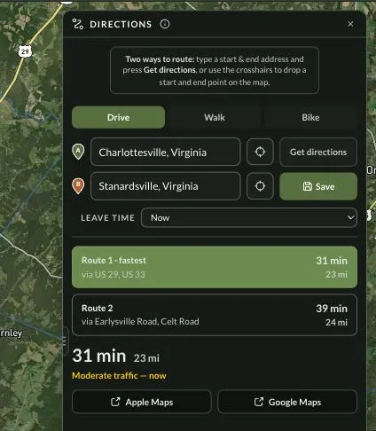
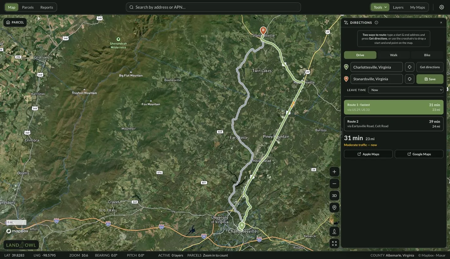
Directions is point-to-point routing built into the map. You set a start and an end, press Get directions, and Land Owl draws the route on the same satellite imagery you were already looking at, with the drive time and distance in the panel beside it.
It answers the question that straight-line distance never does. Rural parcels are separated from the nearest town by rivers, ridges and county-road networks that do not run in straight lines, so the honest measure of "how far out is it" is road miles and minutes, not a ruler.
It routes to parcels, not just addresses. Click a parcel — including one with no street address — and Land Owl uses its recorded location as the destination, so you can measure the drive to raw land the same way you would to a house.
Who is it for?
Anyone whose next decision depends on whether a property is worth the drive, or on how far it sits from something that matters — a highway, a town, a yard, a mill, a job site.
- Land buyers screening a shortlist before spending a Saturday driving it
- Developers and site selectors checking distance to a corridor, an interchange, or a labour market
- Foresters and contractors working out haul distance and crew travel to a tract
- Agents and brokers answering "how far is it from town?" with a number instead of a guess
- Anyone comparing two parcels where the map distance and the road distance disagree
How do you get directions to a parcel?
Open Directions from the Tools menu on the map (or press R). There are two ways to set each end of the route, and several shortcuts that fill one in for you.
Set the start and the end
Type an address or place into either field and pick from the suggestions, or use the crosshair button to drop the point straight onto the map. Drop the start and Land Owl arms the end for you automatically.
Or start from what you were already doing
Right-click anywhere on the map for "Directions from here" and "Directions to here". Search results carry a route icon that sets the destination. A parcel's Actions menu has a Directions entry that sets that parcel as the destination and — if you allow location access — your current position as the start.
Choose how you are travelling
Drive, Walk or Bike. On Drive you can also set Leave Time — now, or a preset like Monday 8:00 AM or Friday 5:30 PM — to see what the trip looks like at the hour you would actually make it.
Read the result
Up to three routes come back with the fastest one flagged, each with its time, distance and the roads it runs on. Click an alternate on the map to compare it. A one-line traffic verdict sits under the selected route on Drive.
Take it with you, or keep it
Apple Maps and Google Maps buttons hand the same start and end off for turn-by-turn navigation. On Basic and above, Save pins the route to the current map so it is there when you reopen it.
What you get with Directions
| Capability | What it actually does |
|---|---|
| Start and end | Two points — type an address, drop a pin on the map, right-click, use a search result, pick a parcel, or use your current location as the start |
| Destination | An address, a dropped pin, or a parcel — including raw land with no street address |
| Travel modes | Drive, Walk, Bike |
| Routes returned | Up to three, with the fastest flagged and the roads each one uses |
| Time and distance | Minutes and hours, miles |
| Traffic | Live congestion drawn on the drive route, plus Leave Time presets for a weekday morning, a Saturday morning or a Friday evening |
| Off-road ends | When a destination sits off the public road network, the route ends at the nearest road and a dashed line and a warning show how far the last stretch is |
| Turn-by-turn | Handed off to Apple Maps or Google Maps in one click |
| Saved routes | Basic and above — up to 10 per map, toggled on and off, re-drawn whenever you reopen the map |
What Directions does not do
It does not give you turn-by-turn navigation, and it is not two points plus stops — it is exactly two points, a start and an end, with no waypoints in between and no route optimisation. Land Owl is for planning the trip, not driving it, which is why the Apple Maps and Google Maps buttons are there.
It routes on public roads only. There are no off-road, trail, ATV or truck profiles, and it knows nothing about gates, private drives, or whether an easement is passable in a pickup. Where a parcel sits off the road network, Land Owl says so plainly — it draws a dashed straight line for the last stretch and tells you how long it is — rather than inventing a track that may not exist.
Distances are in miles only, there is no route export (no GPX, no PDF), and a saved route is stored as the request and its summary rather than as a drawn path — so it is re-fetched each time it renders, and people you share a map with will not see the line.
Related terms
Directions: FAQ
Can I get directions to a parcel that has no address?
Yes. Click the parcel on the map and use the Directions entry in its Actions menu, or drop the end point straight onto it. Land Owl routes to the parcel's recorded location rather than needing a mailing address, which is the normal case for raw land.
Does Land Owl give turn-by-turn directions?
No. Land Owl gives you the route, the drive time and the distance for planning. When you are ready to drive it, the Apple Maps and Google Maps buttons hand the same start and end to your phone's navigation app for turn-by-turn.
Does it account for traffic?
On the Drive profile, yes. Congestion is drawn along the route with a one-line summary, and you can set Leave Time to a preset such as Monday 8:00 AM or Friday 5:30 PM to see the trip at the hour you would actually make it.
What happens when a property is off the road network?
The route ends at the nearest point on a public road and Land Owl draws a dashed straight line to the destination with a warning telling you how many miles the last stretch is. It does not pretend to route down a track it cannot verify.
Can I save a route?
Yes, on Basic and above. A saved route attaches to the map you are working on — up to 10 per map — and re-draws whenever you open that map. Generating a route is free on any plan; only saving one needs a paid plan.
Can I add stops along the way?
Not today. Directions routes between exactly two points, a start and an end. There are no intermediate waypoints and no multi-stop optimisation.
How much does it cost?
Getting directions is included on every plan, including the free one. Saving routes onto a map starts at $10/month billed annually ($20 month-to-month) on Basic.
Stop guessing how far out it is
Route to any parcel on the map — free plan, no card.